
.svg)

.jpg)
How buildings become reliable digital data.
Many projects in existing buildings start with a seemingly simple question: What is actually there?
In practice, this question is often difficult to answer. Plans are outdated, floor area data is no longer correct, conversions have not been documented, or important information is scattered across paper files, PDFs, photos and individual CAD files. For small individual tasks, this may still be manageable. For refurbishments, energy consulting, larger building stocks or entire portfolios, however, it quickly becomes a problem.
A digital building survey starts exactly here. It replaces error-prone manual measurement processes with structured digital data capture, from the building and its floors and rooms through to areas, components and relevant equipment features. Depending on the use case, a simple measurement app may be enough. In other cases, a laser distance meter, a 3D scan or a professional digital survey of the existing building is required.
What matters is not only that dimensions are captured digitally. What matters is what is created from them afterwards:
- reliable three-dimensional building models,
- floor plans, sections, elevations and room books,
- areas, building envelope data or
- a data basis for CAD, BIM, energy consulting and refurbishment planning.
What is a digital building survey?
A digital building survey refers to the digital capture of buildings, floors, rooms, areas, components and dimensions. When a survey is carried out digitally, information is no longer created only on paper or in individual sketches. Instead, it is captured directly in a structured way, stored and prepared for further use.
This can look very different depending on the project. For simple tasks, a digital measurement app or a laser distance meter is often sufficient to capture and document individual dimensions. For more complex buildings, refurbishments or larger building stocks, scanners, 3D laser scanning inside the building or supplementary drones and photogrammetry for roofs and facades are often used.
This is why the term is not always used in the same way in the market. Sometimes a digital building survey means a simple app for individual rooms. In other cases, it refers to a comprehensive digital existing-building survey, where the on-site capture results in three-dimensional building models, plans, room books and structured building data.
For practical use, this distinction is important. The right method depends on what is needed at the end:
- only individual dimensions,
- a CAD survey,
- a BIM-oriented model,
- a digital existing-building survey or
- a data basis for refurbishment, conversion, operation and building stock management.
Why is a digital building survey so important for existing buildings?
Building projects are becoming more data-intensive. Refurbishment, energy consulting, ESG reporting, funding processes, BIM, facility management and portfolio decisions all require reliable information about the existing building stock. At the same time, existing building data is often outdated, incomplete or only available in analogue form.
A digital building survey is therefore particularly important where existing buildings need to be reassessed, refurbished, redesigned or managed. In existing buildings, the most important foundation is often missing: up-to-date and reliable building data.
Many buildings have changed over the years. Rooms have been merged, uses have changed, attics have been converted or technical systems have been renewed. Not every one of these changes later finds its way into the plans. As a result, existing documentation is often only of limited use.
For refurbishments, energy assessments or modernisation projects, this is risky. Energy consultants, architectural offices and specialist planners need reliable planning documents for:
- areas,
- volumes,
- room structures,
- building envelope,
- windows,
- doors and components.
Without such planning documents, measures are difficult to assess, plan or compare. A digital building survey closes this gap and creates a reliable basis for decisions: Which areas need to be refurbished? Which data is missing for energy consulting? Which buildings are suitable for which measures? And which information is required for planning, tendering or operation?
A digital building survey is also relevant for housing companies, municipalities, portfolio holders and facility management. Here, the issue is often not just one individual building, but many buildings. If these are documented differently, building stocks are difficult to compare. A scalable digital survey process creates consistent and reusable data.
Which problems does a digital building survey solve compared with manual measurement?
With manual measurement, information is often created on paper, in sketches, in photos and later in CAD files. This creates media breaks: from the building to the sketch, from the note to the digital file, from the photo to interpretation in the office. Each of these steps can cause errors.
Typical problems include:
- illegible notes,
- incorrectly assigned dimensions,
- missing room references or
- photos that can no longer be clearly assigned later.
Especially in larger buildings, many similar rooms or occupied apartments, this costs a lot of time.
A digital building survey reduces these uncertainties. Rooms, dimensions, photos and notes can be linked directly with each other. This makes it clear which dimension belongs to which room, which photo shows which detail and which data can later be used for models, plans or room books.
An important advantage therefore lies in several points at once:
- On-site capture can be faster, information is recorded in a more structured way and subsequent processing becomes much easier.
- Well-prepared digital survey data can be used to derive different types of results, for example:
- a digital three-dimensional building model,
- floor plans, sections and elevations,
- area lists or room books.
- While manual measurement is often associated first with a single floor plan, a digital building survey can be used much more broadly.
Digital building survey vs. manual measurement: the key difference
Which methods are available for a digital building survey?
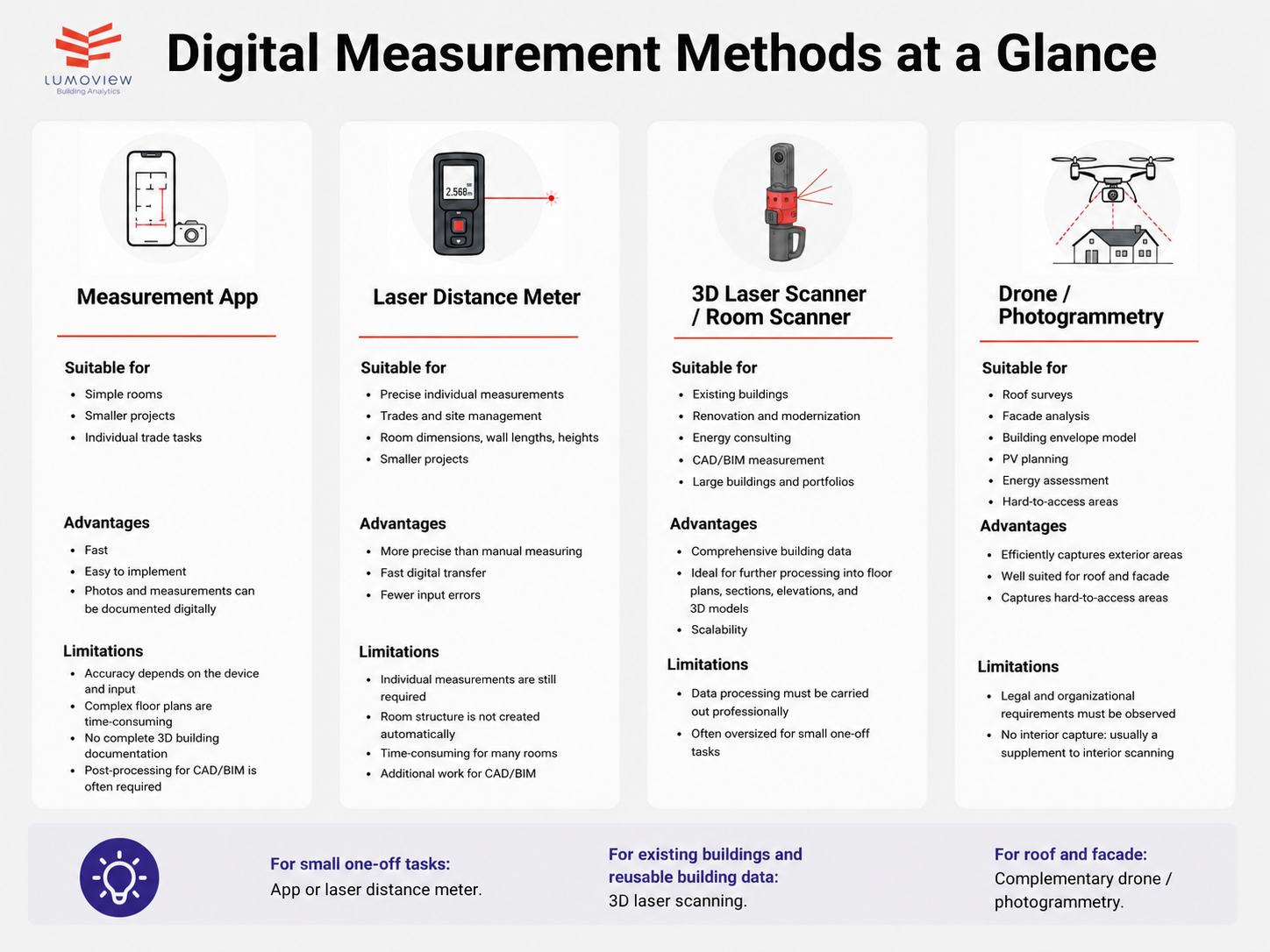
Which method makes sense depends on the project goal. Not every task requires the same technical solution.
1. Measurement app
A digital measurement app is especially suitable for:
- simple rooms,
- smaller projects or
- individual trade tasks.
A survey using an app helps to:
- capture dimensions digitally,
- add photos and
- document information more quickly.
Limits:
- Accuracy depends heavily on input and device
- complex floor plans are time-consuming
- usually no complete 3D building documentation
- post-processing for CAD/BIM is often required
A measurement app is useful when the process needs to become more digital, but a comprehensive building survey is not required. For digital measurement in trade work, this may already be sufficient.
2. Laser distance meter with digital transfer
A laser distance meter with digital transfer, often also referred to as a Disto, measures distances more precisely and faster than a tape measure or folding rule. In combination with an app or measurement software, measured values can be transferred directly. This reduces typing errors and speeds up documentation.
Well suited for:
- more precise individual measurements
- trades and site management
- room dimensions, wall lengths, heights
- small to medium-sized projects
- combination with measurement software
Limitis:
- Measurement points still need to be captured individually
- room structure is not created fully automatically
- time-consuming for many rooms
- transfer to CAD or BIM requires additional effort
A laser distance meter is useful when individual dimensions need to be captured precisely. For large building stocks or complete building models, however, it is usually not sufficient on its own.
3. 3D survey with laser scanner or room scanner
An interior scan, 3D laser scanning or 3D building survey goes much further. Here, not only individual dimensions are captured, but also room geometries and spatial relationships.
Well suited for:
- digital building surveys in existing buildings
- refurbishment and modernisation
- energy consulting
- CAD surveys and BIM surveyslarge buildings and portfolios
- existing building documentationfacility management
Limits:
- Data processing must be carried out professionally
- quality depends on the scan process, software and modelling
- often oversized for very small individual tasks
- professional solutions require clear output formats and interfaces
This is particularly useful when three-dimensional building models, floor plans, sections, elevations or reusable building data are required
4. Drones and photogrammetry
Drones and photogrammetry are suitable as a supplement for the external building envelope, such as roofs, facades or hard-to-access areas. Images are used to create digital models, area information or documentation of the external building structure. They do not replace interior capture, but they can usefully extend a digital building survey.
Suitable for:
- roof surveys
- facade analysis
- building envelope models
- PV planning
- energy assessment
- hard-to-access building areas
Limits:
- dependent on weather,
- access and flight conditionsinteriors are not captured
- legal and organisational requirements must be observed
- often useful as a supplement to an interior scan
Drones are particularly suitable when the roof, facade or building envelope are part of the planning or energy assessment.
Which method is suitable for which use case?
For small individual tasks, a measurement app or laser distance meter is often sufficient. Typical examples include kitchen planning, interior fit-out, individual rooms or smaller modernisation projects.
For apartments, offices or units of use, structured room assignment becomes more important. Here, a digital interior scan can offer advantages because rooms, photos, dimensions and equipment features can be linked more clearly with each other.
For entire existing buildings, complexity increases. In addition to individual room dimensions, floors, staircases, height references, areas, units of use and the building envelope become relevant. In such cases, a more professional approach makes sense.
For large portfolios, scalability is also important. Housing companies, municipalities or portfolio holders often need comparable data across many buildings. In these cases, not only accuracy matters, but also a standardised process and consistent data output.
Which data is created during a digital building survey?
A good digital building survey does not end with a collection of measured values. Its value is created only when the capture is turned into usable results.
Depending on the project, digital three-dimensional building models, floor plans, sections and elevations can be created. A digital three-dimensional model can help to understand the building geometry as a whole and derive the required plans, sections or elevations from it.
Room books, areas, volumes, window and door lists or component lists can also be part of the digital existing-building survey. For energy consulting and refurbishment planning, building envelope data is also relevant: external walls, windows, roof areas, doors and other thermally relevant components.
Which data makes sense depends on the project. In some cases, a digital three-dimensional building model is the central basis. In other projects, floor plans, sections, elevations, area lists or room books are mainly required. Depending on the objective, this can result in a CAD survey for conventional planning or a BIM survey for model-based processes. Often, a combination is useful so that the data can be used both for planning and for later analysis.
Another advantage: a properly structured digital model can remain useful beyond the current project. If something changes in the building later, the model can be updated with the right software and processes and maintained as an ongoing digital basis for the existing building stock.
How does a digital building survey of an existing building work?
- Preparation
A digital building survey does not begin on site. First, it should be clarified which data is needed. Is it only about simple dimensions? Or are three-dimensional building models, floor plans, sections, room books, building envelope data or interfaces to CAD, BIM, CAFM or ERP required?
- On-site capture
This is followed by on-site capture. Depending on the method, rooms, dimensions, photos and building details are recorded using an app, laser distance meter, scanner or drone. In existing buildings, organisation is also important: Which areas are accessible? Are apartments occupied? Are there sensitive rooms or existing plans?
- Data processing
After capture, the data is checked, structured and processed. The desired results are then created, for example models, plans, area lists or room books.
- Use in the project
The processed data becomes especially valuable when it can subsequently be reused in planning, energy consulting, refurbishment, facility management or building stock maintenance. This creates an end-to-end process: from on-site capture and modelling through to use in CAD, BIM, IFC, CAFM, ERP or energy consulting software.
What is especially important in occupied buildings?
In occupied buildings, the issue is not only technology, but also consideration, organisation and data protection. Capture should be as fast as possible and disturb residents as little as possible.
A good digital building survey process reduces the time spent on site. Rooms do not have to be blocked for unnecessarily long periods, furniture does not have to be moved extensively and appointments do not have to be repeated several times.
Correct notification of residents is also important. They should know in good time when the survey will take place, which areas need to be entered and how long the appointment is expected to take. Clear communication makes organisation easier and increases acceptance on site.
Photos must also be used responsibly. They are helpful, but they do not replace structured capture. It is important that images are clearly assigned to rooms, components or equipment elements and that sensitive information remains protected.
For housing companies, municipalities and portfolio holders, the key advantage lies in the combination of short on-site times, clear appointment organisation and structured documentation. When many units of use need to be captured, exactly this combination makes the process more predictable and less disruptive.
How can you identify a good digital building survey solution?
A good digital building survey solution is not defined only by the technology used. What matters is whether it fits the project goal and delivers usable data at the end.
Important criteria include:
- accuracy,
- traceable data quality,
- scalability,
- data protection in occupied buildings,
- ease of use,
- suitable output formats and
- good further processing.
The results should be available in formats that can be used in CAD, BIM, IFC, CAFM, ERP or energy consulting processes.
Accuracy and data quality
Not every project needs maximum detail. Some projects mainly require a reliable three-dimensional building model. Others need floor plans, sections, elevations, room books, areas or component lists derived from it. A good solution should be able to reflect this data requirement properly.
It therefore delivers not only raw data, but understandable results: models, plans, lists and structured building data that can be used for further work.
Scalability
For individual rooms, an app may be enough. For apartment buildings, municipal buildings, districts or portfolios, different processes are required.
A scalable solution should:
- capture many rooms efficiently
- use repeatable standards
- provide data centrally
- document multiple buildings comparably
- output results in a structured way
Data protection in occupied buildings
Data protection is particularly important in existing buildings. When interiors are captured, personal information, image data and usage data must be handled carefully.
Questions to check include:
- How is data stored?
- Are people or sensitive information captured?
- Are there GDPR-compliant processes?
- How short and low-disruption is the inspection?
- Can occupied units be captured efficiently?
Ease of use
A solution can be technically strong but still fail in everyday use if it is too complex. Especially for recurring surveys, ease of use is crucial.
Important questions include:
- Who is supposed to carry out the survey?
- Is surveying expertise required?
- How quickly can the team be trained?
- How reliable is the process in everyday use?
- How much post-processing is required after capture?
Suitable output formats and interfaces
The results should be available in formats that can be used in CAD, BIM, IFC, CAFM, ERP or energy consulting processes.
Lumoview as a solution for digital building surveys in existing buildings
Lumoview does not treat digital building surveys as a single app-based solution, but as a comprehensive process for professional building capture in existing buildings. It combines building capture with the LumoScanner, a patented 3D laser scanner for interior surveying at the push of a button, with the subsequent automated processing of building data.
In the context of digital building surveying, the focus is not only on individual dimensions, but on comprehensive and structured capture, data processing and usable results.
This is particularly relevant when buildings need to be captured quickly, in a structured way and at scale. For example for:
- energy consulting,
- refurbishment planning,
- conversions,
- housing companies,
- municipalities,
- portfolio holders,
- facility management or
- larger portfolios.
Depending on the project, the capture can result in:
- three-dimensional CAD models,
- floor plans, sections and elevations,
- room books,
- building envelope models and
- other structured building data.
External areas such as roofs and facades can also be captured using drone photogrammetry.
Lumoview therefore connects three levels:
- digital on-site capture
- structured processing of building data
- use in planning, refurbishment, energy consulting and operation
This means that the digital building survey does not end with measured values. It becomes the basis for further processes: planning, redesign, refurbishment, conversion, building stock maintenance and building management.
Conclusion: A digital building survey pays off when measured data becomes usable building data
A digital building survey does not merely replace paper, sketches and manual measurement. Its added value is created when on-site capture becomes a structured data basis.
For small individual tasks, a measurement app or laser distance meter may be sufficient. For existing buildings, refurbishments, occupied properties or larger portfolios, however, a professional digital building survey is usually more suitable.
The most important question is therefore not: Which technology is the most modern? Instead, it is: Which data will be needed later?
Anyone who clarifies this question early creates a better basis for planning, redesign, conversion, refurbishment, energy consulting, documentation and long-term building stock maintenance.
FAQ
How accurate is a digital building survey?
Accuracy depends on the method. A simple measurement app is mainly suitable for rough or medium-level requirements. A laser distance meter provides more precise individual measurements. 3D laser scanners or professional room scanners capture entire rooms and building structures much more comprehensively. Another decisive factor is how the data is processed and checked.
Which devices do you need for a digital building survey?
That depends on the use case. For simple surveys, a smartphone, tablet or laser distance meter is sufficient. For professional digital building surveys, 3D scanners, room scanners or supplementary drones are used. Software for processing, documentation and export is also required.
Which is better: measurement app, laser distance meter or 3D laser scanner?
For small projects and simple quotation processes, a measurement app is often sufficient. For precise individual dimensions, a laser distance meter is useful. For existing buildings, refurbishment, CAD, BIM or portfolios, a 3D laser scanner is usually better suited because it captures building structures more comprehensively.
How does a 3D building survey work inside a building?
In a 3D building survey, rooms are captured using a scanner. The measurement data is then processed and converted into usable results, such as floor plans, 3D CAD models, room books or BIM-oriented data. This creates digital documentation of the existing building stock.
Which data is created during a digital building survey?
Depending on the method, the results may include dimensions, areas, photos, sketches, point clouds, floor plans, 3D models, room books, area lists or building envelope models. It is important that the data is provided in suitable formats, such as PDF, DWG, IFC, RVT, Excel or CSV.
Can digital building surveys be used in occupied buildings?
Yes, digital building surveys can also be used in occupied buildings. Short inspection times, clear processes and GDPR-compliant handling of image and measurement data are important. The faster the capture takes place, the lower the burden for residents or users.
How does a digital building survey help with refurbishment and energy consulting?
For refurbishment and energy consulting, a digital building survey provides a reliable data basis. Areas, room structures, building envelope and existing-building information can be used for planning, funding processes, energy assessment, tendering and documentation.
Which interfaces are important?
Important interfaces and output formats include DWG for CAD, IFC for BIM, RVT for Revit, PDF for plans and Excel or CSV for lists and room books. For portfolio holders and facility management, interfaces to CAFM, ERP or energy consulting software can also be relevant.
What does a digital building survey cost?
Costs depend on the method, building size, accuracy requirements and desired result. A simple app is cheaper, but provides less structured building data. A professional building scan costs more, but can be more economical due to less post-processing, fewer on-site appointments and better further processing.
When is a professional building scan worthwhile?
A professional building scan is worthwhile when many rooms, complex building stocks or multiple buildings need to be captured. It is especially useful when the survey is intended to produce CAD data, BIM models, room books, area lists or digital building data for refurbishment, operation or portfolio decisions.
What is the difference between a digital building survey and digital building surveying?
A digital building survey can describe simple digital measurement processes, for example using an app or laser distance meter. Digital building surveying is usually more comprehensive: it captures buildings in a structured way, often three-dimensionally, and prepares the data for planning, CAD, BIM, refurbishment or facility management.