
.svg)
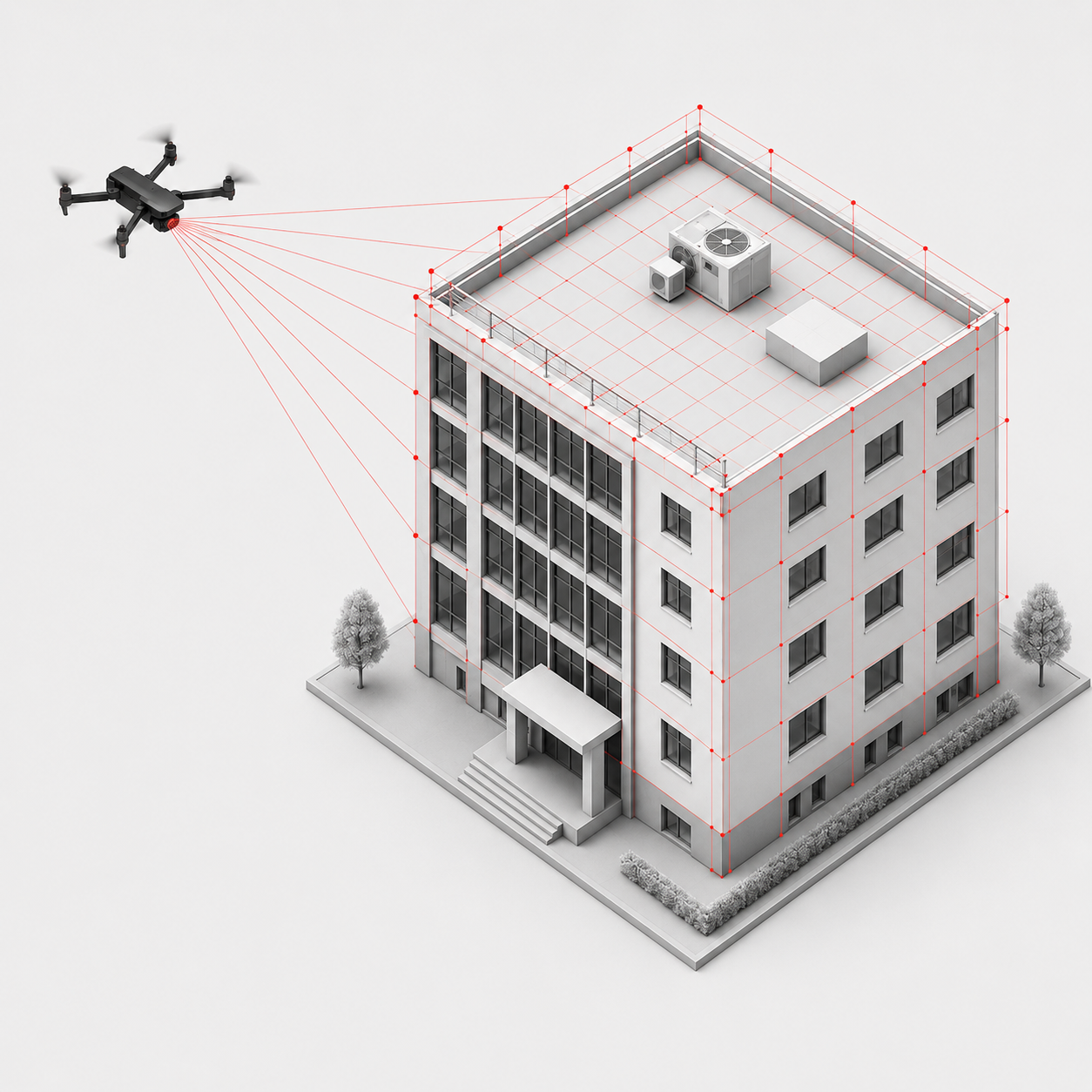
Drone photogrammetry: facade measurement and roof surveying
✓ All building envelope data accurate to the centimetre
✓ 3D CAD instead of 2D CAD data
✓ Only 15 minutes on site > fast, accurate, efficient
✓ Exterior views available immediately > perfect for energy consulting or subsidy applications
✓ Combination with building interior data
✓ Optimal basis for fast, efficient BIM model creation
Comprehensive building data from drone and 3D scanning
Drone photogrammetry provides you with a precise data basis for the digital recording of building envelopes and roofs – without the need for costly scaffolding, aerial work platforms or incomplete inventory plans. Lumoview combines drone photogrammetry for façade and roof surveying with 3D laser scanning of interiors to create a complete, consistent and continuous building model.
Together with our partner Airteam, we reduce the most time-consuming step in building modelling – data collection – to a minimum, while maintaining maximum precision. With digital facade and roof surveying using drones and Airteam's AI-supported software, we create BIM models more efficiently and quickly than ever before. This makes renovation
and maintenance easier and cheaper, and opens up new business models, such as digital energy consulting or heat pump installation.

Benefit of drone photogrammetry
By combining drone photogrammetry with 3D laser scanning of interior spaces, we capture additional data points that enable more precise CAD modeling. This provides clear added value for energy consulting and building analysis, as reliable information about the building envelope is essential alongside the interior model. In particular, this includes data on façade materials and the orientation of building components.
Only 15 minutes on site
Drone photogrammetry enables façades and roofs to be captured faster, more accurately, and more efficiently than ever before. Within approximately 15 minutes on site, all relevant building envelope data is collected without the need for expensive scaffolding, aerial platforms, or incomplete as-built plans.
Exterior views available immediately
Results are available almost instantly. The first exterior views from the drone flight can be reviewed as soon as the drone lands, long before the CAD model is completed. This is particularly useful for energy consulting, funding applications, or project quotations.
3D CAD instead of 2D CAD
Unlike traditional methods, which are often costly and time-consuming and therefore limited to 2D plans, Lumoview’s technology generates 3D CAD data. Digital building twins can be processed in the cloud with a high degree of automation, enabling more advanced modeling and analysis.
Centimetre-level accuracy
Drone surveying delivers centimeter-accurate measurements, far exceeding the reliability of manual measurement methods. This significantly reduces uncertainties in renovation planning and execution, allowing projects to start with highly accurate building data.
Combined with interior scan data
After the drone flight on site, Lumoview combines the scanned Airteam 3D CAD data with the interior data from the 3D laser measurement by theLumoScanner. Depending on requirements, the data includes all relevant façade surfaces, material classes and compass directions – for a complete building model.
Basis for BIM models faster than ever before
By combining building data with interior data, BIM models can be created quickly and efficiently. This simplifies renovation and
maintenance tasks as well as energy consulting and PV planning on complex roofs. Otherwise invisible problems are detected early and prevented.
What is drone photogrammetry?
Drone photogrammetry is a technology that uses drones to take photos of an object, such as a building or landscape.
- The camera is pointed vertically downwards.
- The images overlap by up to 85%, depending on the project requirements, in order to find sufficient matching features and deliver accurate results.
- The data obtained can be used to create precise and detailed 2D maps (orthophotos) and 3D models.
Photogrammetry software: How are 2D images turned into a 3D model?
The 3D models are created using photogrammetric software and stereoscopic evaluation. The software analyses the offset drone images (stereo pair) taken at different angles and determines the three dimensional coordinates (x, y, z) for each object point occurring there. In this way, it generates a three-dimensional spatial image, comparable to human binocular vision, which enables depth perception.
Photogrammetry using drones is a necessary step in creating the database for the building envelope model.
Drone photogrammetry with Lumoview
Lumoview offers drone photogrammetry both as a stand-alone service and as an add on module to 3D laser scanning in order to create a complete
building envelope model. The module includes drone flights and subsequent 3D CAD modelling.
Data surveying
drone flight and overlapping drone images
.avif)
Processing data into a 3d exterior view
The collected 2D images are combined into a 3D exterior view using Airteam software (Airteam Fast Fusion model).
.avif)
Add-on: processing into a building envelope model
Additional model with visible material differentiation (building envelope model): This contains extensive information, for example for the visualisation of
PV systems or insulation measures for sound energy consulting or for individual renovation roadmaps (iSFP).
Our drone partner Airteam takes care of the exterior shots and the creation of the high resolution, true-to-scale 3D building model, the so-called "Fast Fusion Model", using AI-supported Airteam software.
This can then be modelled into a complete building envelope model for you, depending on your specifications. The colour-coded SketchUp contains:
- a differentiation of materials on the exterior surface according to the desired material types
- a differentiation according to compass direction
- a list (Excel export) of all exterior surfaces including area (m²), material/colour codes according to your individual specifications and the compass directions/orientations.
Roof measurement with drone photogrammetry
Another module is roof surveying. We offer three specific applications for this.
- General survey: You receive a standard PDF report with a clear and comprehensible presentation of the roof survey, including areas, angles of inclination and potential obstacles – relevant for maintenance and renovation work.
- PV-add-on: The PV add-on provides relevant planning data for photovoltaic systems, such as solar radiation and roof geometry, in industry-standard file formats – suitable for planning PV systems.
- Individual roof survey: We provide a detailed roof survey according to your individual requirements, for example with regard to file formats, level of detail or specifically defined dimensions.
What data do you receive with drone photogrammetry?
Depending on your requirements, you will receive a classic 3D building model, a building envelope model with material differentiation and compass directions, or a
detailed roof survey according to your individual requirements, for example for planning PV systems.
- For roof surveys, depending on the application, you will receive a clear and comprehensible representation of the roof survey with areas, angles of inclination and potential obstacles, relevant planning data for photovoltaic systems in industry-standard file formats, or a detailed roof survey according to individual requirements, for example with regard to file formats, level of detail or specifically defined dimensions.
- With the classic 3D building model, you receive a digital, centimetre precise image of your building, i.e. a photorealistic 3D model that you can rotate and zoom in your browser. You will also receive an automatic calculation of roof areas, lengths, inclinations and obstructions, as well as a structured survey report in accordance with DIN SPEC 5452-5.
- With the building envelope model, you receive all the necessary data on:
- Orientation/cardinal direction: crucial for the influence of the sun's path. South-facing windows, for example, provide higher heat gains.
- Analysis of existing exterior surfaces, such as the roof area: crucial for analyses and estimates of necessary renovation frequencies.
- Excel export containing all relevant façade surfaces, material classes, surface sizes and compass directions.
To advance consulting procedures and building strategies in energy consulting, we particularly recommend the building envelope model. This is because the classification of building envelope materials and data on exterior wall structures are absolutely crucial for the energy performance of a building: solar gains and thermal insulation influence renovation projects.
Use cases: Who benefits from drone photogrammetry?
Drone photogrammetry has established itself as an efficient and precise method for surveying buildings – especially in the context of energy consulting and energy-efficient renovation. Particularly in decision-making situations where you are comparing technologies and providers, it impresses with its uncompromising accuracy, speed and cost-effectiveness.
Professionals who need efficient inventory surveying of the outer shell and roof clearly benefit from this surveying method, especially energy consultants and architects, but also renovation project managers, engineers, and construction and real estate experts.
As energy consultants
you can optimise your consulting approach and building strategy with a reliable, geometrically precise database for the building envelope. Facade and roof areas, slopes, orientations and relevant details such as material allocation can be recorded accurately and used directly for energy demand calculations, verifications and the individual refurbishment roadmap (iSFP). This reduces assumptions, increases the quality of consulting and builds trust with clients.
As renovation project managers
you will benefit above all from the rapid availability of reliable planning data. Decisions on measures, costs and priorities can be made early on and based on facts with the help of energy assessments, forecasts and floor plans/3D models. This can shorten project durations, as the survey is carried out without interfering with ongoing operations. The process can be comprehensively documented with the help of surveys.
As architects and engineers
you receive more precise CAD and BIM models thanks to additional, high-resolution data points. You can realistically map existing geometries and integrate them directly into your planning. This creates a solid foundation for design, approval and execution.
As construction and real estate professionals
you can use the data obtained to optimise evaluation, documentation and project management. Uniform, traceable inventory data facilitates coordination between all parties involved and increases transparency throughout the entire project.
Frequently asked questions about drone photogrammetry
- Photogrammetry creates 3D models from many overlapping 2D photos, which In a second step, special software triangulates points from several images to create a 3D point cloud – with colour and texture of the surface. Triangulation means that it determines the 3D position of a point by comparing the same image point in at least two (usually many) photos from different angles.
- LIDAR (Light Detection and Ranging), on the other hand, measures distances using laser pulses that are reflected back to the sensor. The drone flies vertically over the building and scans line by line with a line scanner. This results in orthophotos (image mosaics) or photorealistic 3D models (3D point clouds) with very accurate distance values in the first step.
Sprechen sie uns an, um das richtige Verfahren für ihr Projekt zu finden!
- Photogrammetry produces highly photorealistic models with RGB colour information and is comparatively easy to implement and less expensive. However, the process requires a lot of computing power because the raw images do not contain any 3D information. Software must further process the data in post-processing. In addition, only digital surface models are possible, not terrain models: vegetation, such as bushes, must be manually deleted in post-processing. The images are also dependent on light and surface structure: surfaces with little texture, such as water-like, smooth surfaces, are difficult to capture.
- Photogrammetry is suitable for
- Individual buildings and facades
- Excavation pits, small construction sites, quarries and landfills
- Photorealistic 3D models
- Architecture, monument preservation and documentation of the current state
- Small budgets
- Photogrammetry is not suitable for
- very large areas (several km²) → high computing power required ● dense vegetation → ground barely visible
- homogeneous surfaces (water, snow, glass)
- poor lighting conditions
- Photogrammetry is suitable for
- LiDAR delivers very high accuracy, even in poor lighting conditions and dense vegetation. The laser scan directly records thousands of points with their position and distance. The 3D model is therefore contained in the raw data, and post-processing requires only a fraction of the computing power. Unlike photogrammetry, LiDAR also enables digital terrain models: bushes and vegetation can be hidden so that measurements can be taken down to the ground. However, laser scanning is more expensive and often requires special sensors and hardware as well as larger drones, which complicates the approval process. Laser scanning is more suitable for very large surveying projects, such as roads or agricultural land.
- LIDAR is particularly suitable for large, complex and highly accurate surveying tasks, especially where vegetation, poor visibility or accuracy are factors.
Reliable documentation of exterior and roof surfaces is crucial for inventory analyses. The combination of drone photogrammetry and
3D laser scan interior data ensures even more accurate and consistent data. It makes key factors for renovation projects visible and tangible with a 3D model. This allows us to optimise renovation estimates and forecasts.
- Precision instead of gut feeling: you receive reliable data on exterior and roof surfaces, including materials and orientation, thanks to the differentiable 3D model. From tiles and plaster to concrete or glass to roof structures – with a differentiable 3D model, we create reliable foundations for energy consulting and inventory analyses.
- Better decisions: you can develop building strategies and set renovation priorities based on sound information.
- Consistent process: The module is part of our full-service solution – from scanning to the data platform.
There are two basic types: aerial and terrestrial photogrammetry. A special case of the terrestrial form is close-range photogrammetry.
- Aerial photogrammetry for buildings and landscapes uses suitable drones and aircraft for aerial photography.
- Terrestrial photogrammetry for facades and structures uses ground based cameras.
- Close-range photogrammetry is used for high-resolution capture of smaller objects or building details and uses smartphones in addition to special cameras.
No. We provide the delivered data in common, standardised formats. You can process this data using standard GIS, CAD or BIM software.
However, specialised software may be required for specific applications (e.g. point clouds or PV simulations).
- CAD: .dwg, .dxf (AutoCAD), .skp (SketchUp).
- BIM: .ifc (standard format), as well as project-specific .rvt or .bimx.
- PV planning: 3D geometry formats such as .obj (including textures) and .dae, as well as specialised formats for PV*SOL (.pvoen), SMA Sunny Design or SolarMonkey.
The costs depend on various factors, such as your individual requirements and wishes. Contact us for a personalised quote!
Drone surveying with photogrammetry is accurate to the centimetre and completely reliable.
The building should be freely accessible and clearly visible from the air. The use of drones should be permitted under aviation law. For private properties, we require the consent of the owner. There are usually no special structural or technical requirements.
Only a few days. The flight usually takes place within a short period of time, and the subsequent data processing takes one to several working days, depending on the size of the project and the amount of data.
A digital surface model (DSM) shows the Earth's surface along with all objects on it, such as trees, bushes, houses and other buildings. A digital terrain model (DTM), on the other hand, shows the bare Earth's surface without vegetation or buildings.
Yes. The use of drones is legally compliant with the EU Drone Regulation. Responsibility for the flight lies with the qualified drone pilot carrying out the flight. Our partner Airteam acts as an intermediary platform. As the client, you are not responsible for the operation of the drone.

Drone photogrammetry for your projekt!
Get fast and accurate building data for your properties.